Serenity's Kingdom - Portfolio Record
Unit 2 Lesson 6: U.S. Geography Portfolio Day 1 & Enchanted Passport Journal
Student Name: Serenity | Date:
🎯 Part 1: Set Your Journey Goals
Before you begin preparing your 3 portfolio maps (political, climate, and resource maps), write down what you already know and what you want to discover!
✨ Kingdom Vocabulary Vault
Tap each sparkling card below to unlock all 10 essential map reading definitions!
🌡️ Climate Map 🔈
A map that shows weather patterns in a place or region.
🧭 Compass Rose 🔈
Part of a map that shows directions (N, S, E, W).
🔮 Forecast 🔈
To predict the weather.
#️⃣ Grid System 🔈
Vertical and horizontal lines used to find locations.
🔑 Map Key 🔈
Tells what every line, color, and symbol stands for.
🏔️ Physical Map 🔈
A map that shows natural features of places.
🏛️ Political Map 🔈
Shows the location and borders of human-made places.
🌧️ Precipitation 🔈
Rain, hail, sleet, or snow.
🌲 Resource Map 🔈
Shows how natural resources are distributed in a place.
📏 Scale Bar 🔈
Allows you to measure how far apart places are.
Portfolio Quest: Types of Maps 🗺️
Welcome to your Magic Scroll Portfolio quest, Serenity! For this project, you will review types of maps and prepare three maps of your region: a political map, a resource map, and a climate map.
People divide Earth into smaller parts like countries, states, counties, and cities. The kind of map that shows the location and borders of human-made places is a political map.
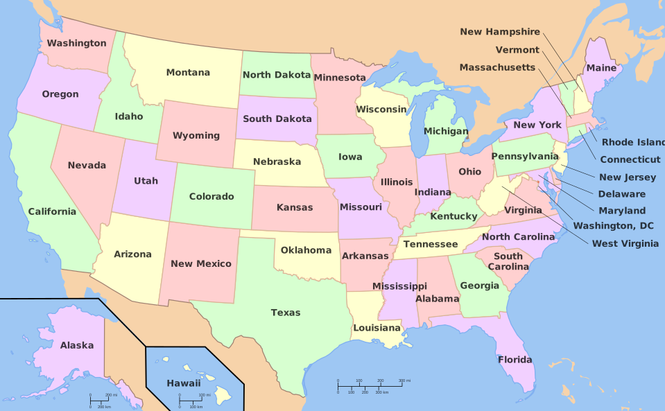
U.S. Political Map
Political maps use distinct colors and border lines to show states. They use a star inside a circle to mark the state capital where the government meets!
Political maps also show major highways, landmarks, and major bodies of water like oceans and rivers so you can see where human-made borders are located in relation to nature.
👩🏫 Learning Coach Guide: Portfolio Tasks & Political Maps
• Portfolio Deliverables: Review the three maps required for Day 1 & Day 2 (Political map with borders/capital, Climate map with weather zones, and Resource map with symbols).
• Discussion: Ask Serenity what symbol is used on political maps to show Harrisburg, our Pennsylvania state capital (a star inside a circle!).
🧚♀️ Sparkle Check 1
What special symbol is used on a state political map to indicate the state capital?
Resource Maps & Climate Maps 🌽🌡️
Natural resources are not distributed evenly across Earth. A resource map shows how natural resources like crops, lumber, oil, and copper are distributed in a place. It helps businesses choose where to build factories and mining companies decide where to dig.
A climate map shows weather patterns over time. It shows temperature variations across a state, yearly precipitation (rain and snow), and climate zones. Special symbols like clouds, raindrops, and snowflakes make climate maps easy to read!
👩🏫 Learning Coach Guide: Resource & Climate Comparison
• Map Distinctions: Reinforce that a resource map shows what goods come from the land, while a climate map shows long-term weather patterns.
• State Thinking: Ask: "What symbols would we put on a Pennsylvania resource map? (Coal, steel, apples, corn, hardwood lumber!)"
Using Map Tools & The Grid System #️⃣
To read a map skillfully, look for its navigation tools: the Map Key (tells what lines, colors, and symbols stand for), the Compass Rose (shows cardinal directions), and the Scale Bar (measures real distances).
📍 The Idaho Grid System Map
A grid system uses vertical lines (numbers 1, 2, 3, 4) and horizontal lines (letters A, B, C, D, E, F) to pinpoint exact locations! Look at the grid below:
By looking at Column 4 and Row B, you can easily pinpoint Pocatello, Idaho at coordinate B4!
🧚♀️ Sparkle Check 3: The Great Map Sort!
Which map type should you use to find the following information? Sort each feature to the correct map!
1. Where the state capital and county borders are located.
2. Where you can find coal mines, pine trees, and corn crops.
3. What the average temperature and weather patterns are over the last decade.
Kingdom Action: Compass Rose Stretch!
Stand up and become a human Compass Rose! Reach high to the sky for North, touch your toes for South, stretch your left arm wide for West, and your right arm wide for East. Hold each stretch for 3 seconds!
Fairy Serenity Says:
"You are now ready to make your portfolio maps on Day 2! Remember to always include a clear title, a map key, and a compass rose on every map you draw!"
📝 Part 2: Complete Your Enchanted Passport Journal
Review your goals from earlier, then record what you learned about map types and how you will create your portfolio maps!
Opens a clean, printable scroll of just your journal to save for your homeschool portfolio!